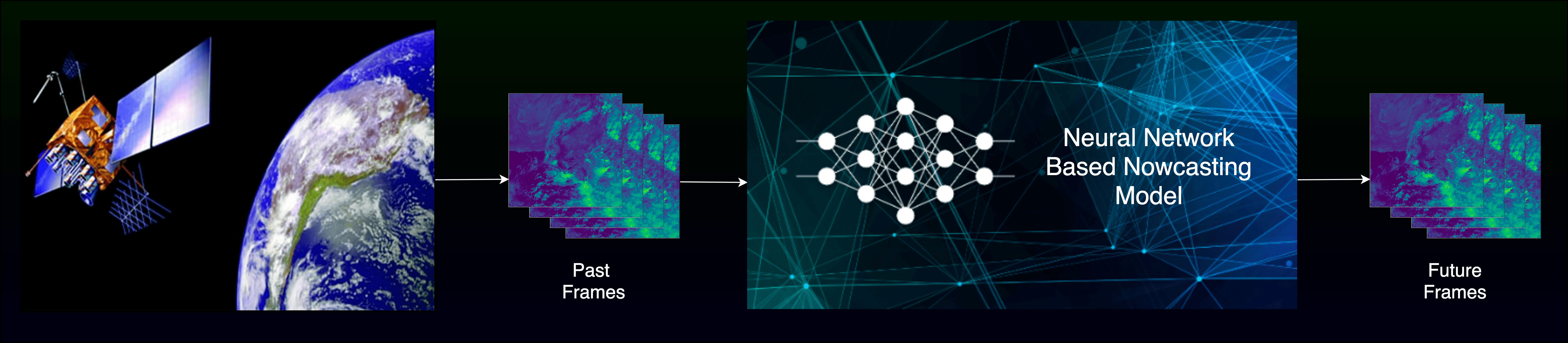
It has been an age-old propensity of Humanity to predict nature’s behaviour, and the weather is no such exception. Because of weather’s capricious and fickle nature and the topical climate change, it has become increasingly necessary to accurately forecast the weather, at least for the shorter period ahead, if not longer. Nowcasting of weather phenomenon is precisely such an endeavour. But, instead of predicting weather from a land-based system, it is quite beneficial to utilise data from space-borne satellites and perform predictions based on them. We propose Deep Neural Networks to predict six future frames from ten history frames separated at an interval of 30 minutes. Our method is developed around the Image-to-Image translation task, and we used a particular variant of U-net Architecture called R2-Unet to predict the future frames. We trained our Network on two months of Meteorological data provided by INSAT-3D, a Meteorological Satellite launched by ISRO, for all six channels viz. VIS, SWIR, MIR, TIR1, TIR2 and VW. Our results up to the 4th future frame are comparable to some previous state-of-the-art satellite image nowcasting under specific constraints. We also proposed another network formulated around sequence to one problem. The model has a multi-scale prediction block consisting of 3D CNNs followed by ConvLSTMs at each scale and a BiFPN-based reconstruction module to combine predicted feature maps to obtain the future image. However, due to a lack of computing resources, the model’s improvement could not be confirmed. Nonetheless, the Network did produce satisfactory results in the initial rounds of training. The inference time of the Image Translation approach demonstrates that pure CNN-based techniques can outperform the previous numerical methods for short duration nowcasting.
Nowcasting of Multispectral Satellite Imagery from INSAT-3D using Neural Networks (Bachelor's Thesis)
Abstract
Technologies:
- - Python
- - Pytorch
- - Rasterio
- - Pandas
- - Numpy
- - Matplotlib
Dataset
The dataset was provided by Indian Space Research Organiation (ISRO) from their geostationary satellite INSAT-3D's Imager. An imager can be compared to a photo camera pointed downwards. Instead of RGB matrix, one can use more wavelengths to distinguish different objects, but the principle will remain the same. The INSAT-3D imager provides imaging capability of the earth disc from geostationary altitude in one visible (0.52 - 0.72 micrometers) {Green to Red} and five infrareds; 1.55 - 1.70(SWIR), 3.80 - 4.00(MIR), 6.50 - 7.00 (water vapor), 10.2 - 11.2 (TIR-1) and 11.5 - 12.5 (TIR-2) bands. The ground resolution at the sub-satellite point is nominally 1km x 1km for visible and SWIR bands, 4km x 4km for one MIR and both TIR bands and 8km x 8km for W.V. band.
Proposed Architecture

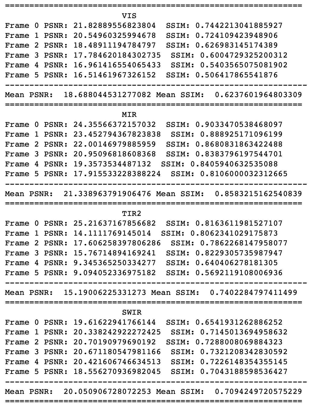
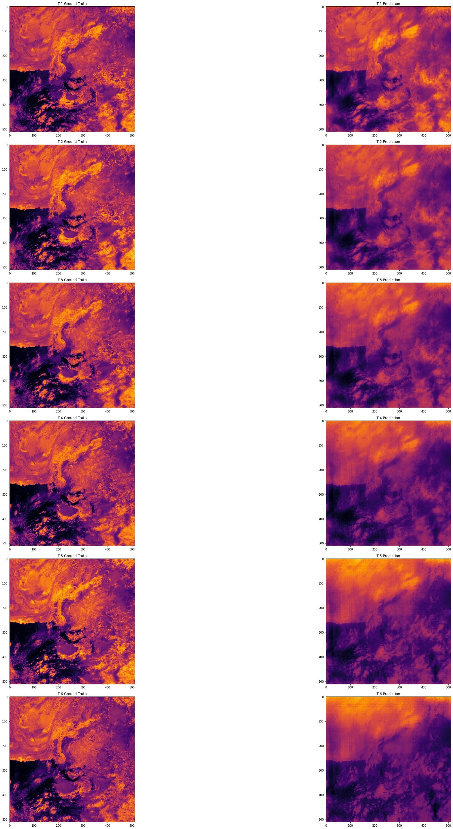
Results